
West Midlands Combined Authority showcase Accelar’s climate risk profile for the region in the wake of COP27
The Context of Climate Adaptation at COP27
As we cast our eyes over the outcomes of COP27, there can be success stories on the path towards a climate resilient future for us all. The new landmark loss and damage deal sets the global political landscape towards integrating climate justice as a key principle in negotiations.
With many keynote addresses stressing the need to shift climate finance towards climate adaptation to create a symbiotic balance with mitigation finance, this is a key reflection on the state of climate change impacts already being seen by many in all corners of the globe. However, the United Nations Environment Programme (UNEP)’s UNEP’s 2022 Adaptation Gap Report has highlighted that the “estimated annual adaptation needs are $160-340 billion by 2030 and $315-565 billion by 2050” and “international adaptation finance flows to developing countries are 5-10 times below estimated needs”.
Our Work to Improve Climate Resilience
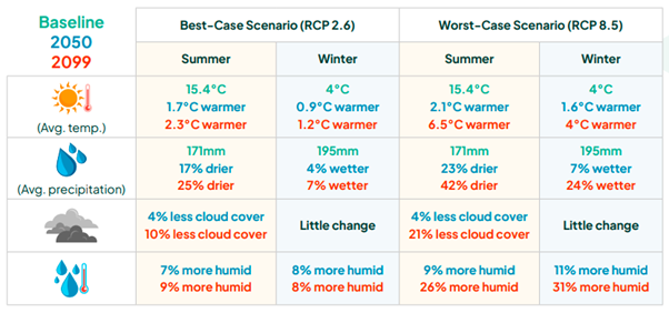
Climate Projections Summary for the West Midlands against baseline period 1981-2000
Closer to home, we have seen major changes in our climate in recent years. Only in July this year we saw a record breaking heatwave , where a Red Extreme heat warning was in place for much of England (including the West Midlands) and Wales. We were commissioned by the West Midlands Combined Authority (WMCA) in collaboration with Sustainability West Midlands (SWM) and Slingshot Design to identify the areas most vulnerable to climate change impacts in the region, helping create the impetus for effective adaptation measures in the region.
To help provide context for the state of the climate and its anticipated changes for the West Midlands region, Accelar made use of the 2018 Met Office UK Climate Projections (UKCP18) and demonstrated that, the West Midlands is experiencing changes to the climate, and these are projected to become more significant over time.
Climate Impact Assessment
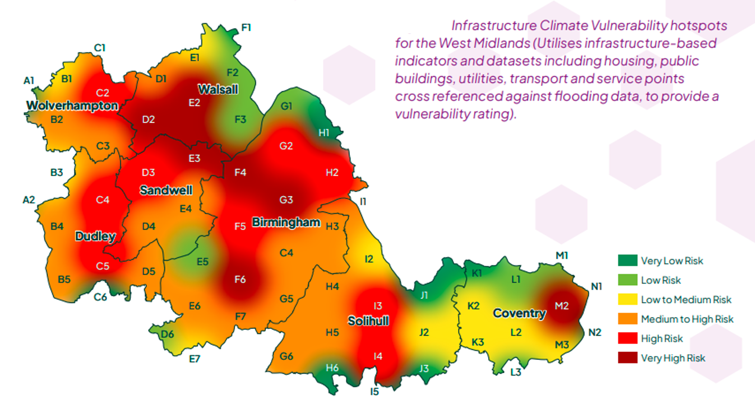
As a result of these climate projections, a tailored climate impact assessment was conducted. This assessment highlighted how different locations in the WMCA area are vulnerable to different risks based on 5km x 5km hexagonal grid locations within the region. This was completed for the impacts on society, infrastructure and the natural environment.
One example was the impact assessment for infrastructure and the findings were summarised in the hotspot mapping.
Summary

Locations of vulnerability for each category
The analysis we conducted begins to paint a picture of what impacts can be expected in the WMCA region, and what this means for society, infrastructure and the environment. Overall the vulnerability hotspots were identified across the region were:
You can read more in the full report here. If you'd like to discuss this work or any of our adaptation assessments, please get in touch so we can help you on your green transition journey.